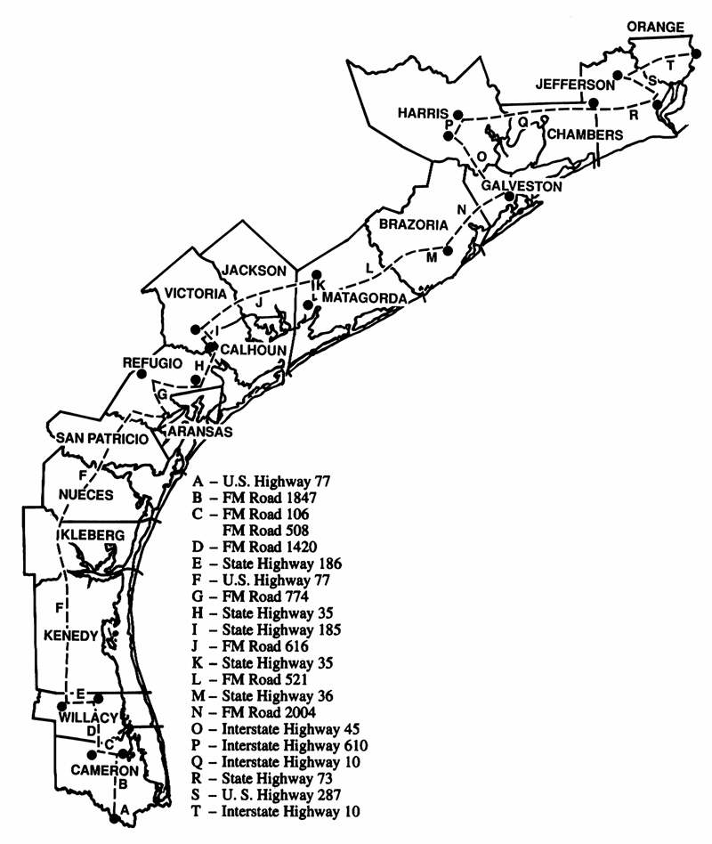
Freshwater/Saltwater Boundary
All public waters east and south of the following boundary are considered salt water:
- beginning at the International Toll Bridge in Brownsville, northward along U.S. Hwy. 77 to the junction of Paredes Lines Road (FM Road 1847) in Brownsville, thence
- northward along FM Road 1847 to the junction of FM Road 106 east of Rio Hondo, thence
- westward along FM Road 106 to the junction of FM Road 508 in Rio Hondo, thence
- northward along FM Road 508 to the junction of FM Road 1420, thence
- northward along FM Road 1420 to the junction of State Hwy. 186 east of Raymondville, thence
- westward along State Hwy. 186 to the junction of U.S. Hwy. 77 near Raymondville, thence
- northward along U.S. Hwy. 77 to the junction of the Aransas River south of Woodsboro, thence
- eastward along the south shore of the Aransas River to the Junction of the Aransas River Road at the Bonnie View boat ramp, thence
- northward along the Aransas River Road to the junction of FM Road 2678 to the junction of FM Road 774 in Refugio, thence
- eastward along FM Road 774 to the junction of State Hwy. 35 south of Tivoli, thence
- northward along State Hwy. 35 to the junction of State Hwy. 185 between Bloomington and Seadrift, thence
- northwestward along State Hwy. 185 to the junction of FM Road 616 in Bloomington, thence
- northeastward along FM Road 616 to the junction of State Hwy. 35 east of Blessing, thence
- southward along State Hwy. 35 to the junction of FM Road 521 north of Palacios, thence
- northeastward along FM Road 521 to the junction of State Hwy. 36 south of Brazoria, thence
- southward along State Hwy. 36 to the junction of FM Road 2004, thence
- northward along FM Road 2004 to the junction of Interstate Hwy. 45 between Dickinson and La Marque, thence
- northwestward along Interstate Hwy. 45 to the junction of Interstate Hwy. 610 in Houston, thence
- east and northward along Interstate Hwy. 610 to the junction of Interstate Hwy. 10 in Houston, thence
- eastward along Interstate Hwy. 10 to the junction of State Hwy. 73 in Winnie, thence
- eastward along State Hwy. 73 to the junction of U.S. Hwy. 287 in Port Arthur, thence
- northwestward along U.S. Hwy. 287 to the junction of Interstate Hwy. 10 in Beaumont, thence
- eastward along Interstate Hwy. 10 to the Louisiana State Line.

The following public waters are not considered salt water:
- waters of Spindletop Bayou inland from the concrete dam at Russels Landing on Spindletop Bayou in Jefferson County;
- north of the dam on Lake Anahuac in Chambers County;
- the waters of Taylor Bayou and Big Hill Bayou inland from the saltwater locks on Taylor Bayou in Jefferson County;
- Galveston County Reservoir on State Hwy. 146 and Galveston State Park Ponds #1 through #7 in Galveston County;
- Lakeview City Park Lake, West Guth Park Pond and Waldron Park Pond in Nueces County;
- Lake Burke-Crenshaw and Lake Nassau in Harris County;
- Fort Brown Resaca, Resaca de la Guerra, Resaca de la Palma, Resaca de los Cuates, Resaca de los Fresnos, Resaca Rancho Viejo and Town Resaca in Cameron County; and
- Little Chocolate Bayou Park Ponds #1 and #2 in Port Lavaca in Calhoun County.